Updated 15 November 2026
North · City of Hume
Craigieburn 3064
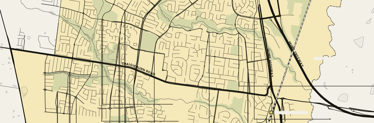
Craigieburn VIC is a large family suburb in the City of Hume, about 26 km north of the Melbourne CBD. Craigieburn station sits inside the suburb on the Craigieburn line, and the trip to Flinders Street takes about 45 minutes. The main shopping centre on Craigieburn Road is a short walk from the middle of Craigieburn.
About Craigieburn
The library sits on Central Park Avenue, and community centres sit on Hothlyn Drive and Waterview Boulevard. Green space follows the creeks at Malcolm Creek Linear Park and Aitken Creek Floodplains. Most homes are separate houses, about nine in ten dwellings.
At a glance
- Area
- 35.44 km²
- State electorate
- Kalkallo (mostly)
- Federal electorate
- Calwell (mostly)
Getting to the CBD
Craigieburn line · Craigieburn station → Flinders Street
45 min to Flinders Street on the 10:15 weekday trainCraigieburn station is 1.6 km from the middle of Craigieburn
Trip notes and all 20 stops
Craigieburn station is the only train station in the suburb, a short drive from the middle of Craigieburn. Trains run south on the Craigieburn line through Broadmeadows and Essendon to Melbourne Central and Flinders Street. The 528 bus runs from the station along Elevation Boulevard.
Craigieburn Start · Roxburgh Park 3 min · Coolaroo 6 min · Broadmeadows 10 min · Jacana 12 min · Glenroy 13 min · Oak Park 16 min · Pascoe Vale 18 min · Strathmore 20 min · Glenbervie 21 min · Essendon 24 min · Moonee Ponds 26 min · Ascot Vale 28 min · Newmarket 30 min · Kensington 31 min · North Melbourne 35 min · Flagstaff 38 min · Melbourne Central 40 min · Parliament 42 min · Flinders Street 45 min
PTV timetable data, retrieved 4 November 2026 · scheduled times; the walk to the station is extra.
01 People
Craigieburn's median age was 32 at the 2021 Census, and couples with children made up about six in ten families. Households average just over three people, and half of residents moved in within the last five years. Nearly half of residents were born overseas.
- People
- 65,178
- Median age
- 32
- Born overseas
- 49%
- Language other than English at home
- 59%
- People per household
- 3.3
- Moved in within five years
- 50%
Show country, language and religion
Australian Bureau of Statistics, 2021 Census, Craigieburn (suburb), retrieved 4 November 2026. Percentages are rounded; the bars show the largest groups only.
02 Schools
Craigieburn has 14 schools inside the suburb and four more close by. Most families start with the government school their street is zoned for, then look at Catholic and independent schools nearby.
Zones that cover most of Craigieburn
Share of the suburb inside each 2027 government school zone.
Primary school zones
Six smaller zones cover the rest: Willmott Park, Newbury, Gilgai Plains, Gamadji, Aitken Creek and Mount Ridley P-12.
Year 7 zones
These zones cover nearly the whole suburb.
All 18 schools in and near Craigieburn
Primary schools
12 schoolsSecondary schools
3 schoolsPrimary and secondary
2 schoolsSpecialist school
1 schoolNo schools match this filter.
Sources: Victorian Department of Education, school locations and enrolments, retrieved 3 November 2026. © State of Victoria (Department of Education), CC BY 4.0; Victorian Government School Zones 2027, share of the suburb's area inside each zone (zones under 5% left out), retrieved 9 November 2026. Student numbers are rounded.
03 Parks
Vic Foster Reserve is the closest to the centre, with Flora Hanson Reserve and D.S. Aitken Reserve a short walk away. Craigieburn Gardens, Amaroo Conservation Reserve and Golden Sun Moth Park are a little further out.
- Vic Foster ReservePark or reserve250 m
- Metropolitan Avenue ReservePark250 m
- Bank Street ReservePark400 m
- Cimberwood Drive ReservePark450 m
Show all 79 parks
- Flora Hanson ReservePark or reserve500 m
- Jacaranda-Wilmott WalkwayPark600 m
- Northern Crescent ReservePark750 m
- Hanson Road Sporting ReservePark750 m
- D.S. Aitken ReservePublic open space750 m
- Rokeby-Dorchester WalkwayPark800 m
- Leigh Court ReservePark950 m
- Silverton-Dorchester-Bisley WalkwayPark950 m
- Flagstaff-Grand WalkwayPark1.0 km
- Redhill-Waterford WalkwayPark1.0 km
- Midhurst-Trecastle ReservePark or reserve1.1 km
- Hamilton ParkPark or reserve1.1 km
- Penny-Swinburne WalkwayPark1.1 km
- Hyde Park ReservePark or reserve1.1 km
- Leigh-Banbury WalkwayPark1.1 km
- Mulberry-White Cedar WalkwayPark1.1 km
- Craigieburn GardensPublic open space1.2 km
- Craigieburn Centennial ParkPark or reserve1.2 km
- Dorchester Street ReservePark1.2 km
- Hamilton Hume ReservePark or reserve1.3 km
- Carlton Court ReservePark1.3 km
- Farhnam-Raheen WalkwayPark1.4 km
- Hambledon-Kelsey WalkwayPark1.5 km
- Olrig FieldPark or reserve1.5 km
- Litton-Carlisle WalkwayPark1.5 km
- Exmouth-Raheen WalkwayPark1.5 km
- Milburn-Bainbridge WalkwayPark1.5 km
- Canisby Way ReservePark1.5 km
- Bowral-Olrig WalkwayPark1.5 km
- Centennial Park Drive ReservePark1.6 km
- Whitby-Windrock WalkwayPark1.6 km
- Highgate Recreation ReserveReserve1.6 km
- Highgate ReservePublic open space1.6 km
- Anzac ParkPark or reserve1.6 km
- Pembroke Crescent ReservePark1.6 km
- Dent-Lydd-Langdon WalkwayPark1.6 km
- Amaroo Conservation ReservePark or reserve1.8 km
- Eastgate Road ReservePark1.8 km
- Tavistock Court ReservePark1.9 km
- Whitney Crescent ReservePark1.9 km
- Norval GreenPark or reserve2.0 km
- Golden Sun Moth Adventure PlaygroundPlayground2.0 km
- Malcolm Creek Linear ParkPublic open space2.0 km
- Brickwood ParkPark or reserve2.0 km
- Golden Sun Moth ParkPark or reserve2.1 km
- Brampton-Brayford WalkwayPark2.1 km
- Waterford ParkPark2.1 km
- Fairways Lake ReservePark or reserve2.1 km
- Grosvenor Square ReservePark or reserve2.2 km
- Aitken Creek FloodplainsPublic open space2.2 km
- Hothlyn ReservePark or reserve2.2 km
- Mount Ridley Conservation ReservePark or reserve2.3 km
- Greenfield Court ReservePark2.3 km
- The Greenway ReservePark or reserve2.4 km
- Henley Court ReservePark2.4 km
- Volcano ParkPlayground2.4 km
- Craigieburn Grassland additional area N.C.R.Park or reserve2.4 km
- Abercarn-Weymouth-Verwood WalkwayPark2.4 km
- Bellfield CommonPark or reserve2.5 km
- Dulwich-Waterdale WalkwayPark2.5 km
- Hume Regional Tennis & Community CentrePublic open space2.6 km
- Hume Tennis and Community CentrePark2.6 km
- Highlands ParkPark or reserve2.6 km
- Abercarn Avenue ReservePark2.6 km
- Rhyolite Drive ReservePark2.7 km
- Malcolm Creek ParkPark or reserve2.7 km
- Burt-kur-min ReservePark or reserve2.7 km
- Clopton Rise ReservePark or reserve2.7 km
- Merri Creek ReservePublic open space3.1 km
- Newbury ParkPark or reserve3.1 km
- Flax-lily Creek WetlandsPark or reserve3.1 km
- Future Conservation Area 27 - Summerhill Road (West), WollertReserve3.3 km
- Aston ReservePark or reserve3.6 km
- John Laffan ReserveReserve5.7 km
- John Laffen Memorial ReservePublic open space5.8 km
Park names and places: hume.vic.gov.au, © OpenStreetMap contributors, retrieved 4 November 2026. OpenStreetMap maps 152 parks, 5 reserves, 57 playgrounds and 1 off-lead dog area for Craigieburn, named or not. Nearest first, measured in a straight line from the middle of Craigieburn.
04 Shops and cafés
The main shopping centre on Craigieburn Road has a supermarket and a pharmacy. Elsewhere on Craigieburn Road you'll find an Indian restaurant and a Middle Eastern bakery, and cafés on Princes Circuit and Glisten Way suit a brekkie stop.
Cafés, food and takeaway 6
Grand Boulevard Cafe
Café27-29 Princes Circuit, Craigieburn 3064WebsiteSmiley's Café & Sweets
Café12 Glisten Way, Craigieburn 3064WebsiteFour Season Pizza & Pasta
Pizza restaurantShop 2, 176 Elevation Boulevard, Craigieburn 3064WebsiteSnappys Pizza and Kebab
Pizza and kebab takeawayShop 3, 439 Grand Boulevard, Craigieburn 3064WebsiteTaste of Amritsar
Indian restaurantShop 2-3, 264 Craigieburn Road, Craigieburn 3064WebsiteManoush w Saj
Middle Eastern bakeryShop 4, 264-270 Craigieburn Road, Craigieburn 3064Website
Show shops and services (11)
Shops and services 11
Bank Street Fish & Chip Shop
Fish and chips15 Bank Street, Craigieburn 3064WebsiteCakes by Nilu
Cake shop37 Gateshead Street, Craigieburn 3064WebsiteColes Craigieburn
SupermarketCraigieburn Central, 340 Craigieburn Road, Craigieburn 3064WebsitePriceline Pharmacy Craigieburn Central
PharmacyShop D00-29, Craigieburn Central, 340 Craigieburn Road, Craigieburn 3064WebsiteTom Lane Pharmacy
Pharmacy70 Central Park Avenue, Craigieburn 3064WebsiteCraigieburn Library
Library75-95 Central Park Avenue, Craigieburn 3064WebsiteCraigieburn Community Services Hub
Community centre120 Hothlyn Drive, Craigieburn 3064WebsiteAitken Hill Community Centre
Community centre40 Waterview Boulevard, Craigieburn 3064WebsiteCraigieburn Education and Community Centre
Community centre20 Selwyn Avenue, Craigieburn 3064WebsiteJUMP! Swim Schools Craigieburn
Swim school18A Gasoline Way, Craigieburn 3064WebsiteCraigieburn Family Medical Centre
Medical centreShop 35, 40 Craigieburn Road West, Craigieburn 3064Website
Listings checked 7 November 2026. Run a business here? Tell us
05 Distances
 ShopsCraigieburn Central550 m
 StationCraigieburn station1.6 km
 HospitalNorthern Hospital10.4 km
 AirportMelbourne Airport12.0 km
 UniversityLa Trobe University, Bundoora17.8 km
 BeachWilliamstown beach31.0 km
| Place | Distance |
|---|---|
| 550 m | |
| 1.6 km | |
| 10.4 km | |
| 12.0 km | |
| 17.8 km | |
| 25.5 km | |
| 31.0 km |
The street map loads here. If it has not appeared, your network blocks the map tiles; every figure on this page stands without it.
Measured in a straight line from the middle of Craigieburn, near Vic Foster Reserve.
Nearby suburbs
All Melbourne suburbs →9 suburbs share a boundary with Craigieburn, from the ABS suburb boundaries, retrieved 4 November 2026. Letters give the direction from Craigieburn.
06 Questions about Craigieburn
How long is the train from Craigieburn station to the city?
A weekday train on the Craigieburn line takes about 45 minutes from Craigieburn station to Flinders Street. It stops at 18 stations along the way.
Which schools are in Craigieburn?
Fourteen schools sit inside the suburb. They include Craigieburn Primary School, Craigieburn Secondary College, Mount Ridley P-12 College and Elevation Secondary College.
Where is the main shopping centre in Craigieburn?
The main shopping centre is on Craigieburn Road, within walking distance of the middle of Craigieburn.
How many people live in Craigieburn?
About 65,000 people lived in Craigieburn at the 2021 Census.
Which council and electorates is Craigieburn in?
The City of Hume covers all of Craigieburn. The suburb crosses more than one electorate, and parts of it fall in the state seat of Kalkallo and the federal seat of Calwell.
07 Sources
32 sources
- Australian Bureau of Statistics, Australian Statistical Geography Standard Edition 3CC BY 4.0 · retrieved 4 November 2026
- Australian Bureau of Statistics, Counts of Australian BusinessesCC BY 4.0 · retrieved 9 November 2026
- Australian Bureau of Statistics, 2021 Census of Population and HousingCC BY 4.0 · retrieved 4 November 2026
- Australian Bureau of Statistics, Postal Areas 2021 (ASGS Edition 3 allocation file)CC BY 4.0 · retrieved 4 November 2026
- Australian Bureau of Statistics, 2021 Census Working Population ProfileCC BY 4.0 · retrieved 9 November 2026
- Victorian Department of Education, Find My SchoolReference only · retrieved 3 November 2026
- OpenStreetMap contributors; OpenFreeMap tilesODbL · retrieved 15 November 2026
- Public Transport Victoria, GTFS scheduleCC BY 4.0 · retrieved 4 November 2026
- Victorian Department of Education, All Schools FTE Enrolments, February 2026CC BY 4.0 · retrieved 9 November 2026
- Victorian Department of Education, Victorian Government School Zones 2027CC BY 4.0 · retrieved 9 November 2026
- Victorian Department of Education, school locations (DataVic)CC BY 4.0 · retrieved 3 November 2026
- Vicmap, Department of Transport and PlanningCC BY 4.0 · retrieved 3 November 2026
- OpenStreetMap contributors via the Overpass APIODbL · retrieved 7 November 2026
- Hume City Council — Bellfield Commonretrieved 7 November 2026
- Hume City Council — Vic Foster Reserveretrieved 7 November 2026
- grandboulevardcafe.com.au — Grand Boulevard Caferetrieved 7 November 2026
- smileyscafeandsweets.com.au — Smiley's Café & Sweetsretrieved 7 November 2026
- fourseasonpizza.com.au — Four Season Pizza & Pastaretrieved 7 November 2026
- snappyspizzaandkebab.com.au — Snappys Pizza and Kebabretrieved 7 November 2026
- tasteofamritsar.com.au — Taste of Amritsarretrieved 7 November 2026
- manoushwsaj.com — Manoush w Sajretrieved 7 November 2026
- bank-shop.edan.io — Bank Street Fish & Chip Shopretrieved 7 November 2026
- cakesbynilu.com.au — Cakes by Niluretrieved 7 November 2026
- coles.com.au — Coles Craigieburnretrieved 7 November 2026
- priceline.com.au — Priceline Pharmacy Craigieburn Centralretrieved 7 November 2026
- tomlanepharmacycraigieburn.com — Tom Lane Pharmacyretrieved 7 November 2026
- humelibraries.vic.gov.au — Craigieburn Libraryretrieved 7 November 2026
- Hume City Council — Craigieburn Community Services Hubretrieved 7 November 2026
- Hume City Council — Aitken Hill Community Centreretrieved 7 November 2026
- craigieburn.org.au — Craigieburn Education and Community Centreretrieved 7 November 2026
- jumpswimschools.com.au — JUMP! Swim Schools Craigieburnretrieved 7 November 2026
- ipn.com.au — Craigieburn Family Medical Centreretrieved 7 November 2026
This page is a guide, not advice. Check zones and timetables with the source before you decide anything. · Map © OpenStreetMap contributors