Updated 15 November 2026
West · City of Melton
Rockbank 3335
Rockbank VIC 3335 has Rockbank station on the Melton line just outside the suburb, near its centre. Trains take about 34 minutes to Southern Cross. The suburb is in the City of Melton, and the Melbourne CBD is about 29 km to the east.
About Rockbank
Old Leakes Road holds the community hall. Rockbank Primary School is the one school inside the suburb, with more schools next door in Aintree. More than eight in ten dwellings are separate houses.
At a glance
- Area
- 4.34 km²
- State electorate
- Kororoit
- Federal electorate
- Gorton
Getting to the CBD
Melton line · Rockbank station → Southern Cross
34 min to Southern Cross on the 10:17 weekday trainRockbank station is 1.0 km from the middle of Rockbank
Trip notes and all 7 stops
Rockbank station is on the Melton line. Trains stop at Caroline Springs, Deer Park, Sunshine and Footscray on the way to Southern Cross. The 140 bus runs to Tarneit station and the 456 to Sunshine station.
Rockbank Start · Caroline Springs 6 min · Deer Park 10 min · Ardeer 13 min · Sunshine 18 min · Footscray 24 min · Southern Cross 34 min
PTV timetable data, retrieved 4 November 2026 · scheduled times; the walk to the station is extra.
01 People
The 2021 Census counted about 2,600 people in Rockbank, with a median age of 31. More than one in five residents were children under 15. More than four in ten residents were born overseas.
- People
- 2,583
- Median age
- 31
- Born overseas
- 44%
- Language other than English at home
- 50%
- People per household
- 2.6
- Moved in within five years
- 78%
Show country, language and religion
Australian Bureau of Statistics, 2021 Census, Rockbank (suburb), retrieved 4 November 2026. Percentages are rounded; the bars show the largest groups only.
02 Schools
Rockbank has one school inside the suburb and six more close by. Most families start with the government school their street is zoned for, then look at Catholic and independent schools nearby.
Zones that cover most of Rockbank
Share of the suburb inside each 2027 government school zone.
Primary school zones
This zone covers nearly the whole suburb.
Year 7 zones
This zone covers nearly the whole suburb.
All 7 schools in and near Rockbank
Primary schools
4 schoolsSecondary schools
1 schoolSpecialist school
1 schoolOther schools
1 schoolNo schools match this filter.
Sources: Victorian Department of Education, school locations and enrolments, retrieved 3 November 2026. © State of Victoria (Department of Education), CC BY 4.0; Victorian Government School Zones 2027, share of the suburb's area inside each zone (zones under 5% left out), retrieved 9 November 2026. Student numbers are rounded.
03 Parks
Ian Cowie Recreation Reserve is a few minutes on foot from the middle of Rockbank. Nash Boulevard Reserve and Stewart Crescent Reserve are not much further.
- Ian Cowie Recreation ReservePublic open space500 m
- Nash Boulevard ReservePark or reserve600 m
- Stewart Crescent ReservePublic open space750 m
- Bridgefield Parkway ReservePark
Show all 9 parks
- Clay Crescent ReservePark
- Cross Lane ReservePark
- Honeydew Way ReservePark
- Lightsview Boulevard ReservePark
- Sedate Drive ReservePark
Park names and places: melton.vic.gov.au, © OpenStreetMap contributors, retrieved 4 November 2026. OpenStreetMap maps 22 parks and 2 playgrounds for Rockbank, named or not. Nearest first, measured in a straight line from the middle of Rockbank.
04 Shops and cafés
An eggless bakery on Innovation Avenue is handy for brekkie, and the general store on Old Leakes Road sells pizza and kebabs. Caroline Springs has the nearest shopping centre.
Cafés, food and takeaway 2
Show shops and services (1)
Shops and services 1
Rockbank Hall
Community hallOld Leakes Road, Rockbank 3335Website
Listings checked 7 November 2026. Run a business here? Tell us
05 Distances
 StationRockbank station1.0 km
 ShopsCaroline Springs Square7.0 km
 HospitalSunshine Hospital14.0 km
 AirportMelbourne Airport17.8 km
 BeachAltona beach21.2 km
 UniversityVictoria University, Footscray Park21.9 km
| Place | Distance |
|---|---|
| 1.0 km | |
| 7.0 km | |
| 14.0 km | |
| 17.8 km | |
| 21.2 km | |
| 21.9 km | |
| 28.7 km |
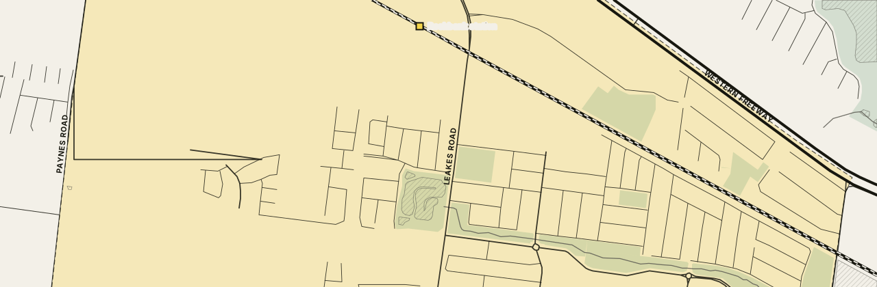
The street map loads here. If it has not appeared, your network blocks the map tiles; every figure on this page stands without it.
Measured in a straight line from the middle of Rockbank, near Lightsview Boulevard.
Nearby suburbs
All Melbourne suburbs →5 suburbs share a boundary with Rockbank, from the ABS suburb boundaries, retrieved 4 November 2026. Letters give the direction from Rockbank.
06 Questions about Rockbank
How long is the train from Rockbank station to the city?
A weekday train on the Melton line takes about 34 minutes from Rockbank station to Southern Cross. It stops at Caroline Springs, Deer Park, Ardeer, Sunshine and Footscray on the way.
Which school is in Rockbank?
Rockbank Primary School, a government primary school on Westcott Parade, is the one school in the suburb. Nearly all of Rockbank is zoned for Yarrabing Secondary College, the nearest secondary school, in Aintree.
How many people live in Rockbank?
About 2,600 people lived in Rockbank at the 2021 Census.
Which council and electorates is Rockbank in?
Rockbank is in the City of Melton. Its state electorate is Kororoit and its federal electorate is Gorton.
Is Rockbank the same as Aintree?
No. Aintree is a separate suburb to the north-east of Rockbank. Aintree Primary School and Yarrabing Secondary College both sit there.
07 Sources
18 sources
- Australian Bureau of Statistics, Australian Statistical Geography Standard Edition 3CC BY 4.0 · retrieved 4 November 2026
- Australian Bureau of Statistics, Counts of Australian BusinessesCC BY 4.0 · retrieved 9 November 2026
- Australian Bureau of Statistics, 2021 Census of Population and HousingCC BY 4.0 · retrieved 4 November 2026
- Australian Bureau of Statistics, Postal Areas 2021 (ASGS Edition 3 allocation file)CC BY 4.0 · retrieved 4 November 2026
- Australian Bureau of Statistics, 2021 Census Working Population ProfileCC BY 4.0 · retrieved 9 November 2026
- Victorian Department of Education, Find My SchoolReference only · retrieved 3 November 2026
- OpenStreetMap contributors; OpenFreeMap tilesODbL · retrieved 15 November 2026
- Public Transport Victoria, GTFS scheduleCC BY 4.0 · retrieved 4 November 2026
- Victorian Department of Education, All Schools FTE Enrolments, February 2026CC BY 4.0 · retrieved 9 November 2026
- Victorian Department of Education, Victorian Government School Zones 2027CC BY 4.0 · retrieved 9 November 2026
- Victorian Department of Education, school locations (DataVic)CC BY 4.0 · retrieved 3 November 2026
- Vicmap, Department of Transport and PlanningCC BY 4.0 · retrieved 3 November 2026
- Melton City Council — Ian Cowie Recreation Reserveretrieved 7 November 2026
- Melton City Council — Nash Boulevard Reserveretrieved 7 November 2026
- Melton City Council — Bridgefield Parkway Reserve, Clay Crescent Reserve and othersretrieved 9 November 2026
- rsbakehouse.com.au — RS Bakehouse: Eggless Bakeryretrieved 7 November 2026
- rockbankpizza.com.au — Rockbank General Storeretrieved 7 November 2026
- Melton City Council — Rockbank Hallretrieved 7 November 2026
This page is a guide, not advice. Check zones and timetables with the source before you decide anything. · Map © OpenStreetMap contributors